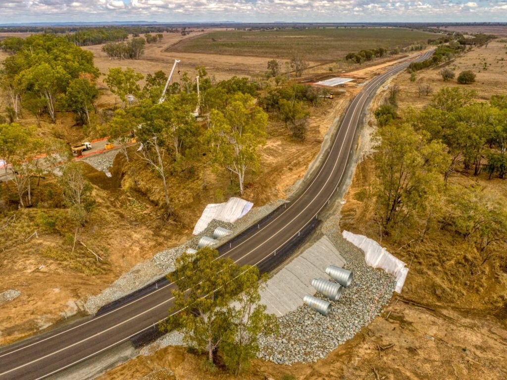
This project involves the upgrading of road intersections and sections along Booyal Dallarnil Road, Paradise Dam Road, and nearby locations to meet the operational and safety standards required for the main Paradise Dam Improvement Project. The upgrades will include major intersection improvements and associated roadworks, such as pavement reconstruction and drainage enhancements. The works will take place across remote sites, requiring effective traffic management plans due to high-speed rural traffic. The project aims to improve the functionality and safety of key road connections, with works primarily focused on intersection upgrades and road realignments.
Scope of Works:
Realignment and pavement reconstruction
Embankment widening
Improvements to property access
Signage and linemarking works
Drainage works and drainage structures
Intersection improvements, including three major intersections:
Booyal Dallarnil Road and Bruce Highway
Booyal Dallarnil Road and Paradise Dam Road
Gooroolba Biggenden Road
Clearing and grubbing
General earthworks
Pavement construction (unbound and lightly bound)
Bitumen sealing works
Installation of guardrails
Traffic management plans and long-term traffic arrangements
Location
Pearces Creek NSW 2477
Client
Ballina Shire Council
Head Contractor
Hazell Bros (QLD) Pty Ltd
Type of works
Bridges
Overall Project Value
$5M
Status
Completed (Feb 2023 - Dec 2023)
The Pearces Creek Bridge Replacement project involved replacing the existing four-span timber bridge on Eltham Road over Pearces Creek, located on the boundary of Lismore City and Ballina Shire LGAs. The new reinforced concrete bridge, built on the downstream side of the existing structure, was designed to support two-lane traffic and meet a 100-year design life. The project incorporated the installation of new substructures and superstructures via dual crane lifts and included the demolition of the original timber bridge.
Scope of Works:
Bridge Construction and Demolition:
Implementation of staged long-term traffic guidance schemes with traffic control.
Piling and construction of reinforced concrete abutments.
Installation of five 32m Super T Girders using dual crane lifts.
Demolition and removal of the existing timber structure.
Earthworks and Pavements:
20,000 m³ of cut/fill earthworks with complex rock subgrade treatments.
Construction of 6 m high embankments approaching the bridge structure.
Flexible pavement construction (800 m), completed adjacent to a live roadway under a traffic guidance scheme.
Environmental and Miscellaneous Works:
Fauna protection, material stockpiling, and riverine environmental management.
Installation of cross drainage structures, concrete batter chutes, and vegetation clearing.
Topsoil placement, landscaping, and wearing course installation.
Line marking, signage, and other road furniture.
Project Highlights:
Constrained Site and Innovative Solutions:
Piling and crane pad design enabled safe delivery within tight site constraints.
Temporary weir river crossing, approved by NSW Fisheries, provided access to both abutments for heavy equipment, reducing interaction with local road users.
Girder Delivery Challenges:
Managed complex logistics for delivering 32 m girders on rural roads, addressing bridge load limits, low-height bridges, and horizontal curve alignments.
Traffic Management:
Conducted three traffic switches of the existing roadway.
Implemented a full road closure detour for critical works, contributing to early project completion.
Utilities Coordination:
Liaison with Essential Energy to temporarily lower overhead powerlines for piling and girder installation. Power was maintained for stakeholders using generators during critical works.
Location
Pimpama, QLD 4209
Client
City of Gold Coast
Head Contractor
Hazell Bros (QLD) Pty Ltd
Type of works
Roadways, Bridges
Overall Project Value
$14M
Status
Completed (Sep 2022 - Dec 2023)
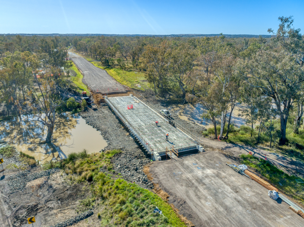
The project involved constructing a new three-span concrete bridge (63m long, 10m wide) over the Pimpama River, along with associated approach works. It included ground improvement, environmental management, and detailed bridge construction.
Scope:
Construction of the new three-span concrete bridge, including provision for a future 2m pedestrian footpath, including:
Cast-in-place piles with liners at abutments and piers.
Abutments and wingwalls for future pedestrian walkway.
Precast prestressed deck units, relieving slabs, bridge kerbs, and rails.
Grouted rock pitching, waterproofing membrane, and deck penetrations.
Asphalt surfacing for bridge and road approaches, traffic barriers, and cyclist rails.
Conduits for future lighting, fauna crossings, and access ramps.
Drainage, batter slope protection, navigational signage, and bridge date plate.
Road traffic barriers and end terminals.
Protection of existing services.
Ground improvement works, including the design and installation of 2,800 Controlled Modular Columns.
Rock spill protection at both abutments, concrete retaining walls, and scour protection on both northern and southern approaches.
445m of bridge approaches connecting to the existing road, with stormwater drainage, signage, and pavement marking.
Landscaping, revegetation, and site restoration, including vegetated filter strips.
Vegetation clearing, site preparation, and removal/reinstallation of road furniture.
Temporary access tracks, storage areas, and environmental approvals for temporary works.
Construction of temporary piling and crane platforms, including waterway work.
Traffic management and control on-site and off-site.
Piling works over water using 1.5m diameter steel-lined cast-in-situ piles up to 40m deep, with dewatering and acid sulphate water management. Construction of a 6.8m high, 130m long retaining wall, and managing access restrictions.
Design and construction of access to the creek, managing significant environmental constraints.
Pavement construction using cement-treated materials and complex traffic management due to nearby swamp land and overhead powerlines.
Environmental management, including work within the tidal zone, acid sulphate soil management, and marine fauna and flora protection.
Location
Griffin QLD 4503
Client
Moreton Bay City Council
Head Contractor
Hazell Bros (QLD) Pty Ltd
Type of works
Roadways, Flood mitigation
Overall Project Value
$19.2M
Status
Completed (May 2022 - Oct 2023)
The upgrade of Henry Road and Dohles Rocks Road in Griffin successfully improved flood immunity and enhanced overall traffic and pedestrian safety. The project involved constructing a new signalised intersection at Dohles Rocks Road and Henry Road, upgrading access to the proposed Griffin Sports Complex near Elizabeth Road, creating dedicated bus turnaround areas, and implementing various safety and flood improvements. Key works included raising road levels and constructing culverts to mitigate flooding risks, improving the road surface, and installing traffic signals to optimise traffic flow.
Scope of Works:
Rehabilitation and widening of existing pavement.
Construction of new traffic medians, line marking, and road furniture.
Installation of traffic signals and a signalised pedestrian crossing.
Comprehensive stormwater drainage upgrades, including soft soil improvement and surcharge embankments with monitoring.
Replacement of soft soil and treatment/removal of unsuitable materials, including acid sulfate soils.
Construction of approximately 420 linear metres of stormwater box culverts (ranging from 600x300mm to 2700x900mm).
Installation of 1500m of subsoil drainage.
A mix of cast in-situ and precast headwalls and bases.
Development of new concrete pathways, kerb ramps, bicycle ramps, and driveways.
Upgrades to street lighting, landscaping, wayfinding signage, and green infrastructure.
Key Outcomes:
Significant flood immunity improvements through road elevation adjustments and extensive drainage enhancements.
Improved connectivity and safety with the addition of cycling lanes, concrete footpaths, and a formalised school bus stop.
Sustainable outcomes achieved with the integration of green infrastructure and landscaping.
Location
Mount Edwards, QLD 4309
Client
Department of Transport and Main Roads
Head Contractor
Hazell Bros (QLD) Pty Ltd
Type of works
Roadways
Overall Project Value
$10M
Status
Completed (Feb 2023 - Oct 2023)
The project involved civil works to upgrade and transform the Cunningham Highway and Lake Moogerah Road intersection, improving safety and operational efficiency along a key section of the National Land Transport Network.
Pavement widening and rehabilitation of the Federal Highway, including a major intersection upgrade with:
Upgraded road design standards: re-grading, superelevation corrections, adverse crossfall adjustments, and curve easing through advanced survey and profiling techniques.
Enhanced sightlines and added channelised left/right turn lanes, extended turning lanes, and wide centreline treatments.
Over 3,800m³ of excavation, with disposal of unsuitable material and replacement using 2,700m³ of high-quality Class A1 fill (CBR-compliant).
Cuts and fills exceeding 5m, including trimming of narrow, constrained subgrades.
Rock protection placement in challenging terrain, coordinated to minimise disruption.
Pavement subgrade treatment using Type B methodology, employing high-quality Class 1A fill to address black soil and marginal materials.
Installation of multi-layer granular pavements (2,500m³), including Type 2.5, 2.3, and 2.1 unbound gravels, with geocomposites (MRTS58) at subgrade level.
Heavy-duty asphalt pavements with deep-lift EME2 and Stone Mastic Asphalt (SMA):
2,650 tonnes of medium-duty dense-graded asphalt and SMA.
4,200 tonnes of EME2 asphalt.
23,500m² of asphalt geosynthetics (MRTS104).
Pavement layers included:
Emulsion prime, C170 seal, two geosynthetic layers, multiple EME2 layers, waterproofing, and SMA.
Significant longitudinal joints with existing pavements, requiring meticulous execution.
Major drainage upgrades, including a 5-cell culvert (4m depth) across the Cunningham Highway, delivered with:
Accelerated 1-week construction proposal under shuttle flow conditions.
Temporary traffic management and geotechnical solutions for steep batter stabilisation.
Special foundations using replace-and-remove techniques for long-life concrete mixes.
Installation of subsoil drainage at various locations.
High-traffic volume (7,000 AADT, with 30% heavy vehicles).
Complex staging to maintain two-way traffic during peak periods.
Project
Intersection upgrade and safety widening Angela Road – Etna Creek Road
Location
Angela Road to Etna Creek Road, Rockhampton QLD
Client
Department of Transport and Main Roads
Key works
Roadways
Status
Completed 2022
The scope of works included widening and reconstruction of 6.1kms of road. Realignment of Greenlakes Road intersection and 640m of new road construction on Dawson Road for realignment of the intersection.
462m of Culvert drainage extensions and complete new lines from 375dia to 1650dia
3.6 X 1.5 & 2.4 X 12 Box Culverts to creeks and existing watermain
210m of Lining existing culverts (CIPP)
Pipe Jacking under Hwy
110,850m3 of Earthworks
42,150m3 unbound pavements
Watermain realignment
Electrical street lighting to intersections
Prime and sealing to pavements
Asphalt to intersections
3,400m of Guard and motorbike rails
Signage and line marking
Kerbs and concrete traffic islands
Project
Byron Bay Bypass
Location
Byron Bay NSW
Client
Byron Shire Council
Key works
Roadways
Status
Completed 2021
Hazell Bros completed the construction of the town centre bypass to the west of the rail corridor along the Butler Street road reserve in Byron Bay. The Bypass connects the southern and northern ends of the Byron Bay CBD for through-traffic with road corridor approximately 1km long, easing traffic con-gestion within the CBD allowing traffic to flow smoothly.
The scope of works were primarily constructed within the existing developed and undeveloped Butler Street road reserve and consisted of:
Upgrade of Butler St, from north of the existing drainage culvert to the southern extent of the existing pavement (approx. 500m)
3x new roundabouts on both Butler and Jonson Streets
Greenfield extension of Butler St, south through the un-formed road reserve wetland area to the rail line (approx. 500m)
A new level crossing
Construction of an extension of Browning St through the existing car parks on Council’s land to the rail line
Demolition, clearing & grubbing, earthworks including dewatering & soft soil foundation stabilisation, drainage, road pavements and surfacing, kerbing, line marking, concrete medians & roundabout aprons, shared path, signage, fencing, guideposts & bollards, retaining walls, driveways.
Project
Fitzroy Bridge Upgrades
Location
Banana Creek, Callide Creek, Roundstone Creek, and Sandy Creek, QLD
Client
Department of Transport and Main Roads
Key works
Bridges
Status
Completed 2023
The scope of works included the demolition of existing timber bridges and construction of 3 new bridge structures and associated roadworks, and the widening of a fourth bridge with approach works.
Banana Creek
Side track construction and replacement of the existing timber bridge at Banana Creek with a 2-span reinforced concrete bridge, with 1km of road widening and upgrades.
Callide Creek
Side track construction and widening of the Callide Creek Bridge structure from 6.7m to 9.2m (between kerbs) and associated approach works, including the reconstruction of the existing pavement with geometric corrections.
Roundstone Creek
Side track construction and replacement of existing timber bridge at Roundstone Creek with a 4-span reinforced concrete bridge structure, flood improvements at the eastern and western overflows adjacent the bridge site as well as an intersection upgrade to Glenmoral Roundstone Rd.
Sandy Creek
Replacement of the existing timber bridge at Sandy Creek with a 3-span reinforced concrete bridge, and associated approach works.
Project
Mount Lindesay Highway – Rosia Road to Stoney Camp Road
Location
Park Ridge South, QLD
Client
Department of Transport and Main Roads
Key works
Roadways
Status
Completed 2020
This project involved widening of a 1.4km section of the high-way from one lane in each direction to two lanes in each di-rection, including associated shoulders, on and off ramp and adjacent bus stop area. Project elements included:
Construction of 1400m3 of concrete lined drains and 1100m of culvert installation of various sizes from 375RCP to 6 cell 1050 RCP across Mount Lindesay Highway
24000m3 of excavation and 15000m3 of embankment works
Construction of two 1200mm by 25m retaining walls and 3000m3 reinforced earth embankment with 800m soil nails and 110m3 of Shotcrete
Placement and compaction of 11500m3 of plant-mixed foam bitumen
7000 tons of AC14 intermediate course and 2200 tons of open graded asphalt surfacing course
Construction of a 583m (1200-1900mm high) split carriage way barrier, two 75m transition barriers and 2000m (1200mm high) single slope barriers
Installation of 38 streetlights (combination of single and double outreach) traffic loops and CCTV cameras
Project
Strathpine – Samford Road Route Safety Project
Location
Eatons Hill, QLD 4037
Client
Department of Transport and Main Roads
Key works
Roadways
Status
Current @ August 2024
Hazell Bros is working on the Strathpine-Samford Road Route Safety Project, locally known as Eatons Crossing Road and Mount Samson Road. This key road connects Eatons Hill and Samford. The project aims to improve safety and efficiency along the Strathpine-Samford Road corridor. Key elements include signalising major intersections, widening specific road sections, and installing a wide centre line treatment to enhance vehicle separation.
The detailed scope of works includes, but not limited to:
Signalising the Eatons Crossing Road and Lilley Road intersection, Warner.
Widening Strathpine-Samford Road just west of Queen Elizabeth Drive to Gibbons Road.
Installing a wide centre line treatment to provide additional separation between vehicles travelling in opposite directions.
Shoulder widening to provide additional trafficable area to pull over, assist emergency vehicles to pass, accommodate wide vehicles and greater separation between cars and bike riders.
Providing safety barriers at various locations and removing roadside hazards (including necessary vegetation clearing).
Modifications at several intersections including dedicated right-turn lanes at Dawneta Court, Albion Road, Lascelle Court, Boland Court, Hodge Road, Lergessner Road, Lawson Road, Alpine Drive and Gibbons Road.
Installing a dedicated left-turn lane at Clear Mountain Road, Hodge Road, Lergessner Road, Alpine Drive and Gibbons Road to separate turning vehicles from through-traffic lanes.
Improved bike rider safety with 2m wide shoulders marked with bike symbols and intersection conflict points marked with green paint and bike symbols.
Provision of new police enforcement bays at identified locations.